The best thing about walking a canal is that you cannot get lost. It’s there, it’s big and if you stay on the dry side it’s nigh on impossible to go wrong. It’s hard to lose a canal.
But I managed it this time.
But before we set off, meet my wingmutt.
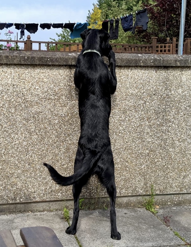
- H before he waived his anonymity. He’s a mutt from mid Wales, product of an accidental encounter between a blonde of excellent pedigree and a dark brooding type down from the mountains. It’s a story as old as the hills.
Huw belongs to our newly wed daughter and son in law. When they said that they were thinking of getting a dog, my reaction was predictable.
DONOTGETADOG, DONOTGETADOG, DONOTGETADOG.
They got a dog.
DON’T EXPECT ME TO LOOK AFTER HIM WHEN YOU’RE AT WORK
He comes to me once a week. Tuesday’s Huw’s day.
We had a couple of dogs in the family when I was growing up but I’m clueless when it comes to canines. First surprise was that young dogs must not be overexercised. No more than five minutes per month of age is the rule. We’ve been building up but haven’t walked very far until now. That is not to say he has not raced hell for leather miles in happy pursuit of his ball in the park so I reckoned that at 9 months he could probably manage a few miles of canal walking.
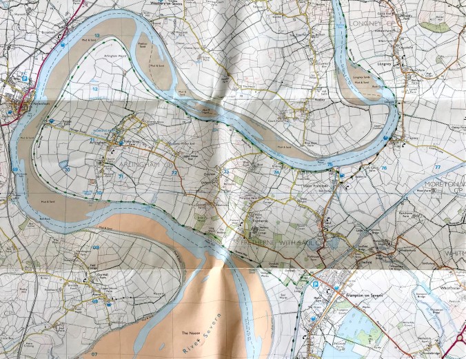
OL14. Thank you, Ordnance Survey
So we jumped in the car and headed up to Gloucestershire to the Arlingham peninsula. It’s an extraordinary quirk of topography – a meander in the Severn – which has created this almost-island no longer on the way to anywhere. Upper Framilode, now a backwater to a backwater, was once the starting point of a very early pair of canals linking the Severn with the Thames (and thereby the Atlantic with London). The first part – the Stroudwater – was built in the 1770s to join the wool town of Stroud with the Severn, so as to bring coal across the river from the Forest of Dean and beyond to power the looms.

An 1988 guide to what are now known as the Cotswold Canals. Handford covers the Stroudwater, and Viner the Thames and Severn and their writings are joined together in the middle. Much like the canals themselves
The Stroudwater is only seven or so miles long but traffic had ceased upon it by the 1930s and it was officially declared moribund in the 1950s. Nails were rammed into its coffin when it was truncated by the construction of the M5 motorway and the improvements to the main A38. (I am indebted to Michael Handford for his in depth, no stone unturned, account of the Stroudwater). My Dad, a civil engineer who spent many years devising plans for schemes to meet the demand for water from the burgeoning south east, recalls a colleague’s pet project to lay a pipe the length of the canals to channel Severn water into the Thames and thus into the drinking water of Londoners. It didn’t come to anything but it does illustrate the extent to which the canal was perceived as redundant.
But times change and, given the revived interest in boating, there is now a move afoot to restore the canals and reopen the route.

A contemporary plan of the meeting of the Stroudwater Canal with the River Severn. Thank you, Michael Handford. My red scribble shows the bit that has since been infilled and turned into a very des res.
What strikes me as a major problem is that the first lock and its ancillary land and buildings – that’s the bit at the entrance to the canal from the Severn which I’ve ham-fistedly marked on the plan – has long been sold off, filled in and turned into a private home and rather a nice garden. There is no watery way through and I don’t think they are going to take kindly to the arrival of the diggers. But the energetic people bent upon canal restoration have a plan and it’s a nifty one.
Anyway, let’s get on with the walk. Turning away from Lock House, there it is. Rather green and weedy but undeniably recognisably a canal. There’s a row of charming canal side cottages and a couple of old pub buildings, one still very much in business. Not much further and the canal is completely choked up.
Then it’s over a stile, follow the footpath, and – hang about – where’s it gone? Now we’re by a waterway but it’s definitely not a canal.

Where did the canal go?
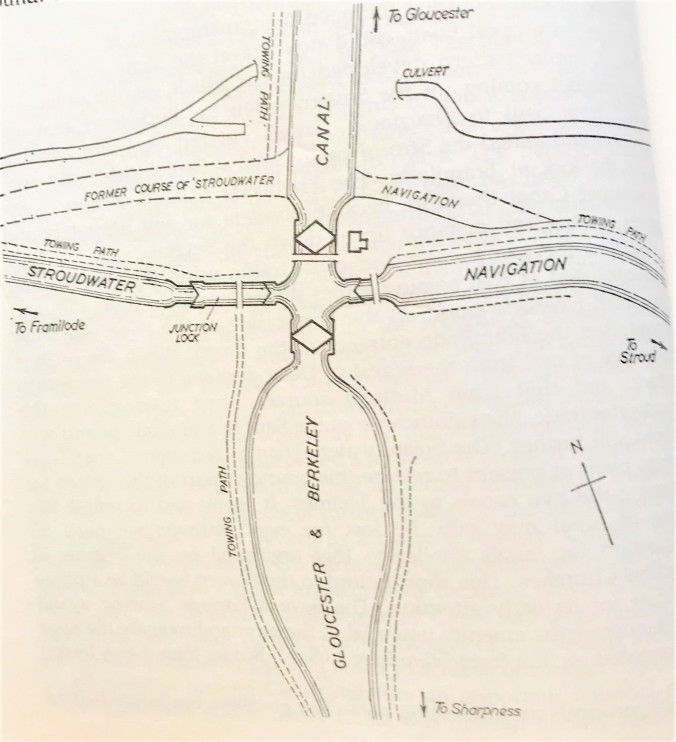
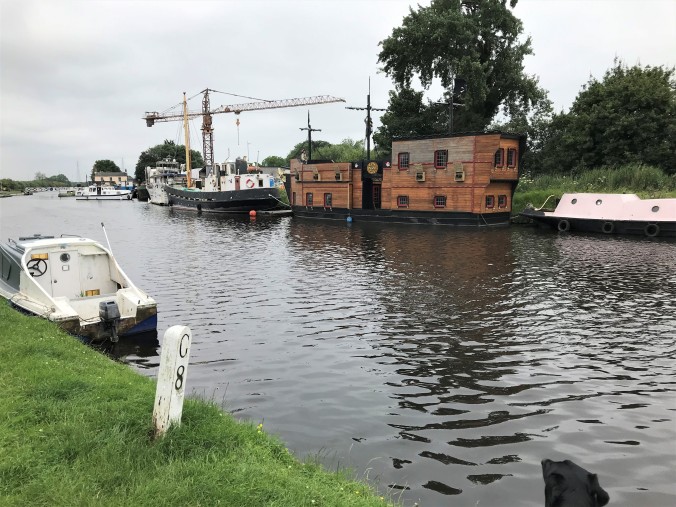
Another dog walker tells me it’s the River Frome. Hmm. We plough on. Not much further and we’re in the grounds of a school boathouse and then straight out onto the wide expanses of the Gloucester and Sharpness canal. Yes, it’s an intersection, a canal crossroads and all a bit exciting as there’s a lot going on here.
Looking over as the Stroudwater crosses the Gloucester & Sharpness
Along a bit to one side is the remnants of the lock which evened up levels of the G&S and the Stroudwater (How come I didn’t come out there? Where’s the canal been in the interim?), across the bridge is the old Junction house and over on the diagonal is a fascinating looking boat builders’ yard,

The boatbuilders’ yard. What’s that lifeboat doing there?
behind which is a new marina, excavated since my 1999 map was published.  Suddenly it’s all busyness and here is the answer to the canal restorers’ dilemma of how to link the Thames to the Severn. Forget the stretch I’ve just walked, leave it to slumber, but instead direct boaters southish down the G&S to meet the Severn at Sharpness.
Thank you again, Michael Handford
Nifty indeed, eh? (see https://wordpress.com/post/womanwalkingblog.wordpress.com/1505 for a bit about that neck of the woods).
Carrying on along the Stroudwater was plain sailing for a bit before the broad, straight way gave out and the map told me to take a detour along a road for a short way. This is the Thames and Severn Way and it’s an officially recognised long distance path. Not on the ground hereabouts it’s not. I saw one sign, just one. In a completely unhelpful place. Hmm, again.
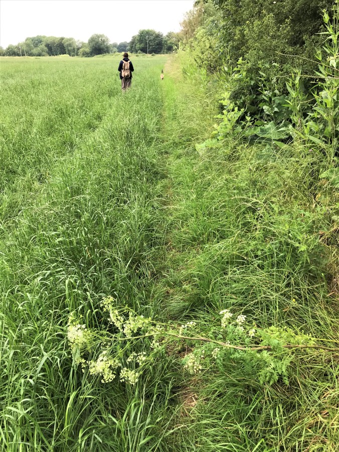
From here on it was a bit of a game of hide and seek. Seek the canal, seek a sign of the path that is marked on the map but not on the ground. Light relief came in the form of another dog walker on a way through the long grass that I was not 100% sure was actually a path. She was bent double but straightened up when she saw me and explained that she’d been doing her back exercises (I can think of easier places to do them, but go ahead) and that her handbag sized pug had a thing about pups which is why he was letting rip at Huw (How could he tell? He’s enormous). We were in the midst of an interesting conversation about I forget what when her eye caught something in the hedge.
Oh my God, that’s henbane
What’s henbane?
It’s what they used to kill Socrates.
Really? Isn’t that cow parsley?
That’s the thing, it looks like wild carrot but it’s got the blood red streaks along the stem. It’s lethal, don’t go near it.
How much would you have to take to kill you, I asked. She didn’t know. So we stood in a field and Googled it for a bit. Then thought that perhaps that was the sort of question you posed on someone else’s phone, not your own.
Actually, I don’t think that henbane is the right name. But I can’t remember what it is.
That rather ended the conversation so we moved the dogs away from the poison tree and parted.
It’s hemlock, not henbane. Five or six leaves should do it.
We came to a bridge over the river. We’d lost the canal again. The map indicated that it was over yonder at the far side of the field but that if we continued to follow the river we’d end up where the two waterways met. I didn’t fancy either plan. There was a third option – take the way that Ms Henbane had presumably come along. That would lead us back towards Frampton on Severn and the map promised that we could divert back to the G&S canal in a big loop. Good. Farewell Stroudwater, you’ve had your chance.
This turned out to be a great bit of walking, through fields high with crops, edged with poppies and cornflowers and yes, cow parsley (or wild carrot/Nottingham lace/Anthriscus sylvestris. I checked for blood red streaks and found none).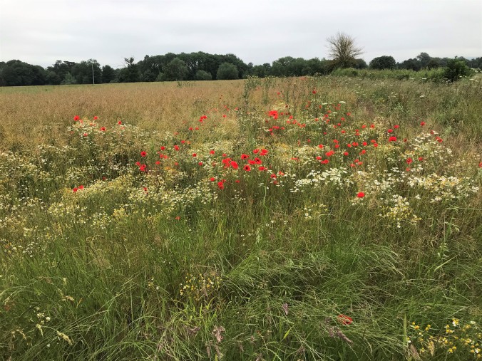 Birds were singing and on the breeze drifted the church bells sounding the quarters.
  There was the dog and there was me and there was no one else about. It was all completely and utterly lovely.
At the end of the field we had a choice: follow the signposted path straight on or take the (not signposted but mapped) track to the right. Forward would get us to Frampton on Severn but would mean a longer walk back to the car for Huw, right would cut out a large corner. Now I am the Ordnance Survey’s greatest fan but even I have to admit that they do have a weakness when it comes to how they mark their tracks. Footpaths, bridleways and other rights of way are marked in red or green depending on the scale of the map. Thoroughfares are marked according to their road designation and can be assumed to be public access. But tracks, those little roads marked in narrow black lines, how does the map tell you whether they’re private lanes or not? It doesn’t. It leaves you to work it out for yourself.

That’s definitely a track, isn’t it?
I could see the track, I could see how it lead to the roadway across the field, I could see it wouldn’t take us into anyone’s back garden, and I could see that it looked about as well walked as the definitely public access path we’d just come.
This was signposted as a public footpath
So I took a chance and we turned right.
After a mile or so, even Huw’s confidence in my decision was faltering. But before we got chapter and verse on this we had to contend with the gate. On the other side was the road, behind us a long walk back. In the way was a chained and padlocked gate surmounted with barbed wire.

Happily I couldn’t see this sign until I was over the fence. Sorry for trespassing, Oatfield Farm. It was an oversight.
No room to wriggle through the hedge so it was over the top for me and through the middle for him.
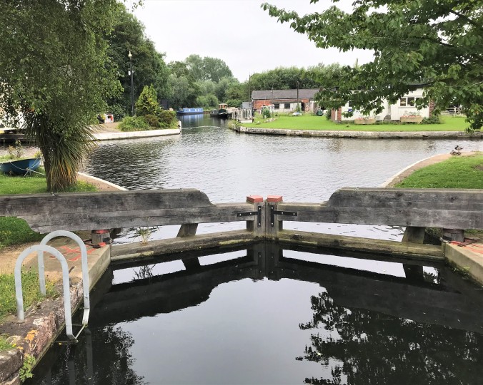
Back on the side of the law, we were soon at the swing bridge over the wide Gloucester & Sharpness canal and then over to the far bank and headed for the café. As Ms Henbane had hinted it was not great (she’d heartily recommended the one in Frampton on Severn instead but it wasn’t on our route). Never mind. Huw was beginning to flag and we still had a couple of miles to go. I had a bottle of water for him and his bowl so I poured him a couple of dishfuls which he slurped down. I know nothing about dogs but I wanted to get him something to eat so I went into the café to see what I could find. I do know now that chocolate kills dogs (tell that to the dogs we had when I was child) but I reckoned everything else on offer would be ok. The rock cake looked the least unappetising so he and I shared one as I drank a cup of tea. It was more a 80:20 split than a 50:50 one as it was ghastly, but he loved it. Next day I learned that dried fruit kills dogs too. What with the hemlock, the barbed wire, and the lethal currants this outing was turning into one death defying moment after another.
But these things happen in threes so we staggered on after our break.
Approaching the junction again. Gloucester 8 miles.
After the mild perils came the stories. A man packing up his fishing stuff on the canal bank began to chat. This man, a plumbing and heating engineer (didn’t like school, no good at exams but give me a length of pipe and it all makes sense…) had paid to have his family tree researched. All that had been found appeared to have come as a surprise to him. My grandfather, now he was a plumber too. Never knew that. Must be in the blood. And my grandmother on my mother’s side, turns out she was illegitimate. She was brought up by her grandparents who lived on a farm around here and I was doing some work for the doctor who lives just on the corner over in (he named somewhere I’d never heard of) and I saw that the address was similar so I asked him. And he said that the farm was next door to him. I never knew that. He knew the woman. Said to call round. 90 years old and always first in the pub, the lady is, he said.
Did you go?
No.
Do you know why they left the farm?
No idea. But you’re from Bristol then? Some of my ancestors went there but then they came back again. But guess what? I had my DNA analysed too and guess what it found from my blood?
(I think I know what you’re going to say)
I’m 2% Nigerian. I’m Nigerian from the knees down.
It took a while to take our leave of the plumber, a genial man who was simultaneously excited about his family history without being at all curious about what was beyond the genealogist’s report. Plots of several novels were spilt out onto the bankside right there – the love child grandmother, the farm that was left behind, the African forebears – but he wasn’t about to pick them up.
The final stretch of the walk took us off the Gloucester & Sharpness canal and back along the Stroudwater spur again. Outside the pub there was an elderly man sitting on the edge of the canal, legs in the water. Another conversation. Another story. This time a comedy.

The expanse of canal directly in front of the pub.
The man’s accent was so broad that I couldn’t understand a word he said. Eventually, after some pantomiming of Huw wanting a swim and me not letting him, I got my ear in. He was pulling reedlike vegetation out of the canal and once he’d finished the ones he could reach he said he was going to go out in his boat and pick up a load more.
That Mrs Rees – Owen, she always says she can’t understand why the water’s clear down here but it’s never that way up her end. She never sees me doing this. And I never tell her.
And, because these things happen in threes, on to the churchyard for the final story: a tragedy. And a mystery.
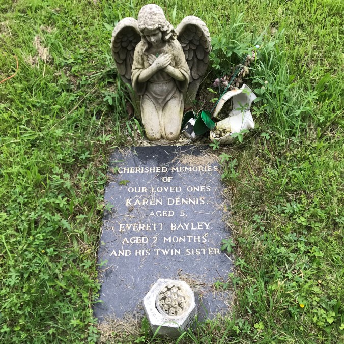
Such a tragic loss to one family. But why the different names? And why was the twin sister never named?

This is fascinating, I need to come back and read through it again, but it seemed quite a walk! And yes what is that with the headstone?
LikeLike
Thank you, Jude. Yes, that headstone – it feels intrusive to wonder, doesn’t it?
LikeLike
Not at all. The sort of headstone that makes me want to do some research!
LikeLiked by 1 person
Great adventure. Loved getting lost and the peace and quiet of this walk with you. I am more used to seeing the Stroud canal up in Stroud near where my parents live. I am always amazed a) that such massive spaces can slit up b) volunteers/diggers can clear them out again!
LikeLiked by 1 person
Thank you, Emma. That’s very kind of you. I have a vague plan to walk the length of the canals with Huw and I’ve seen a little of the canal up beyond Stroud already and I find it astounding that much was built by simple picks, shovels, and navvy brawn. And yes, how quickly it’s faded into dereliction.
LikeLiked by 1 person
I wonder if the unnamed twin died at birth and was never named and the other child held on a bit longer? All sad, though. I was walking through the glorious churchyard of a local town yesterday, reading the headstones. They are almost all from the 18th century and stunningly carved in copperplate. Also churchyard has been left very much to its own devices…such young names…so many who died in one family…everybody has a story, I find. Please give Huw a hug from me. I love the back of his head.
LikeLiked by 1 person
Yes, I thought that too about the twin sister but not to have given her a name must have made it so much harder to mourn her surely? If she was buried there wouldn’t she have had to have had a birth certificate? Can a baby be registered without a name ? Or maybe she died before birth and is only remembered here. All these questions. No dates shown so this could all have been a long time ago when things were different.
And yes, I’ll certainly pass on your hug to Huw. He is a great harbinger of happiness.
LikeLike
So near and yet … Wait a few years and the plan is to reopen the Stoudwater Navigation from Eastington through to Saul Junction, near Frampton on Severn, to link up with the G&SC and the national canal network ‘They’ have to negotiate the mainline railway bridge nr Stonehouse (currently too narrow for the canal) and the M5 (canal filled in) but when it’s all complete, you’ll be able to walk, cycle or cruise from Saul Junction right to my front door and have tea. And cake. The stroud canal is right before me as I write in my study and the Frome just beyond that. I love it. Give it another chance one day, it’s really worth it. D
LikeLiked by 1 person
What a great view you must have from your study. Assuming that you’ve engaged the reed pulling services of the elderly gent and you are not, like Mrs Rees-Owen, puzzling over the lack of clear water… Yes, Huw and I will be back to the Stroudwater at some point but we’re going to give the whole A38/M5/railway line business a miss and start again on the other side. ‘They’ve’ got a massive amount to do on the Severn side but good luck to them. It’ll be a great route cross country when it’s done. Anyhoo- Huw’s off on his hols for a bit now but we’ll be back. I navigate by refreshment opportunities so you had me at the word ‘tea’. Ceri
LikeLiked by 1 person
Hi Ceri, the Cotswold Canal Trust keep the water clear up here as we have no Mr Rees-Owen. Their work barges chug past our window dredging and cutting back vegetation very regularly. I’d suggest parking at Eastington and walking into Stroud along the canal. And then get a bus back to Eastington to pick up your car. Let me know when you come if you fancy company for part or even all of the walk. D
LikeLiked by 1 person
Thank you. I’d love company. I’ll be in touch. Ceri @mrs.miniver
LikeLike