I begin in a spirit of reconciliation.
Portreath – it’s not you, it’s me. It’s not that you’ve done anything wrong, it’s just that I’ve found you a little, well, odd.
It’s not that I expect to find every little spot along the way set up please me and the rest of the carrot cake eating classes. I really don’t. To be brutally frank, St Ives, I find you just a little bit too much with your artisan meringues that could crush a hamster; Newlyn, I love your quay with your stand there and look if you must attitude (but get out of the way of the forklifts because don’t you go forgetting that this is actually an industrial area); and Hayle, you’ve had better days, but your regeneration projects are looking great and everyone loves a trier.
But Portreath? You’re none of these and I just can’t work you out. Your harbour’s commercial life ground to a halt fifty years ago, and now you’re like a place turned in upon itself, a post-industrial spot cold-shouldering the huge expanses of golden sand at the end of the street. And in a part of the world where everywhere else has its eye on the grockle geld, I find this unusual.
Anyhow, I’ve got that off my chest so let’s look at this bunch of happy kids having a lovely time on your sands and move on. (See, I said it’s not you, it’s me).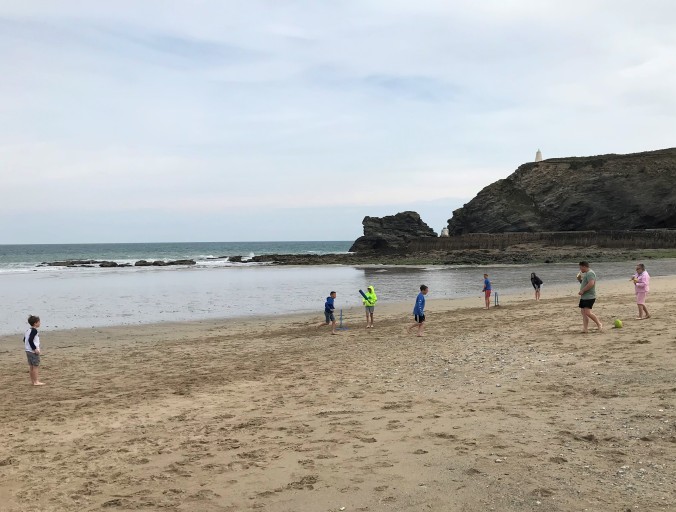
When I planned these few days in Cornwall I had envisioned striding out as far as Perranporth but what are plans for if not to be changed? Two and a bit days of walking turned into one and a bit when I woke up on our second morning, looked at the weather and thought meh. Instead T and I headed off for a day of ambling at Heligan (lovely) and Mevagissey (also lovely). And so it was on the third day that we packed up and left our cottage and headed back to Portreath to get just a little further along the path before we had to hit the A30 for the drive home.
Porthtowan was the new destination and, though a short three mile stroll, the map suggested that it could be a more interesting few miles than the previous outing. There was an airfield on the headland just above Portreath for a start. Although it was shown as in use on my 2003 map (a charity shop bargain – it’s not as though they are going to move the sea, are they?), it was marked as disused on the 2015 version I consulted in the library before I left home (just making sure). From across the bay, I’d seen that there is still a giant golf ball there so I was curious to see if the path would allow me a closer look.
I was quickly up and out of Portreath and passing remnants of wartime buildings across the fields.  A bit of Googling when I got home told me that the airfield – formerly RAF Portreath – dates from 1940 and served as a Fighter Command station, a ferry stop-over for aircraft bound to/from North Africa and the Middle East, a temporary stop-over for USAAF and RCAF units, and then as a Coastal Command station. In 1950, its day was done so most of the site was returned to the government although today it remains a listening post with its long-range radar coverage of the south western approaches to the UK. That’s what’s in the golf ball. I got this from www.forces-war-records.co.uk/units/667/raf-portreath and there’s a whole load of other information out there on the place, but I was soon lost in a sea of abbreviationsand defence jargon (it’s Remote Radar Head Portreath now, by the way). I have never served in the military nor, other than my father’s National Service, have I known anyone spend time in the Forces so this is all a very foreign field to me.
Back to the walk.  Without knowing any of this history at the time, the golf ball led to me assume that something was still going on in there, but the screaming of the stock cars racing up and down the runways on a Sunday morning suggested that the site was otherwise pretty much demilitarised. So the plethora of signs came as a surprise. There was this one, rather weatherbeaten and faded, which looked like it’s been there a while.
 But these looked pretty modern for a disused base.
")
")
I didn’t notice the fence at first. The coast path runs its whole length alongside – and in some case through – privately owned land so it is normal to be separated from the adjoining fields by fence, wall, or bank. Only in extremis would it occur to me to try to access that land.  But this pristine fence went on and on, even after the noise of the race cars was fading away behind me, and even in the face of the steepest of climbs it traced its unwavering line.

Someone really doesn’t want anyone going in there.
At the top of the hill I found myself in amongst more remnants of wartime defences, platforms on which (I’m guessing) munitions were placed and a watch kept, with a trench dug to allow personnel to come and go undetected. It was a lonely spot, bleak on a late spring day, hard to imagine how it would have been on a winter’s night when the threat of invasion was real.
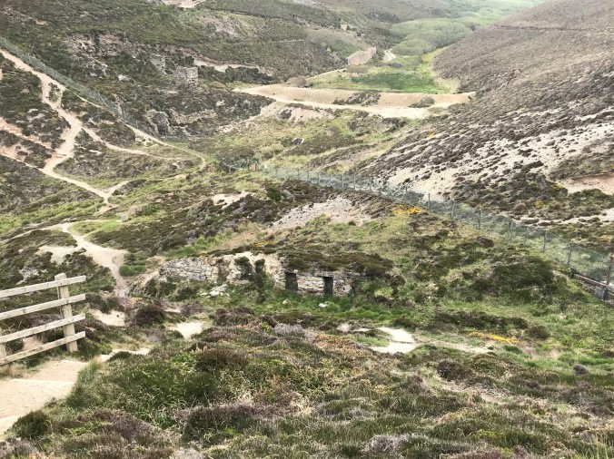
A little further on was this. Another military reminder? No, it’s the protective capping of a disused mine shaft. I was away from old defences and back amidst the remains of the tin and copper industries which straggle along this coastline. Those rungs were strange. Their stopping after a couple of metres suggested that the bottom was close below.
  It wasn’t. I dropped a stone to see how long it would take to hit the base. I didn’t hear it land.
Along the way were the preserved residues of Wheal Tye mine, with maps and interpretation boards (that shaft is 600 feet deep – sheesh) and a chimney painted with a faded graffitied protest of which I could make out only the last word.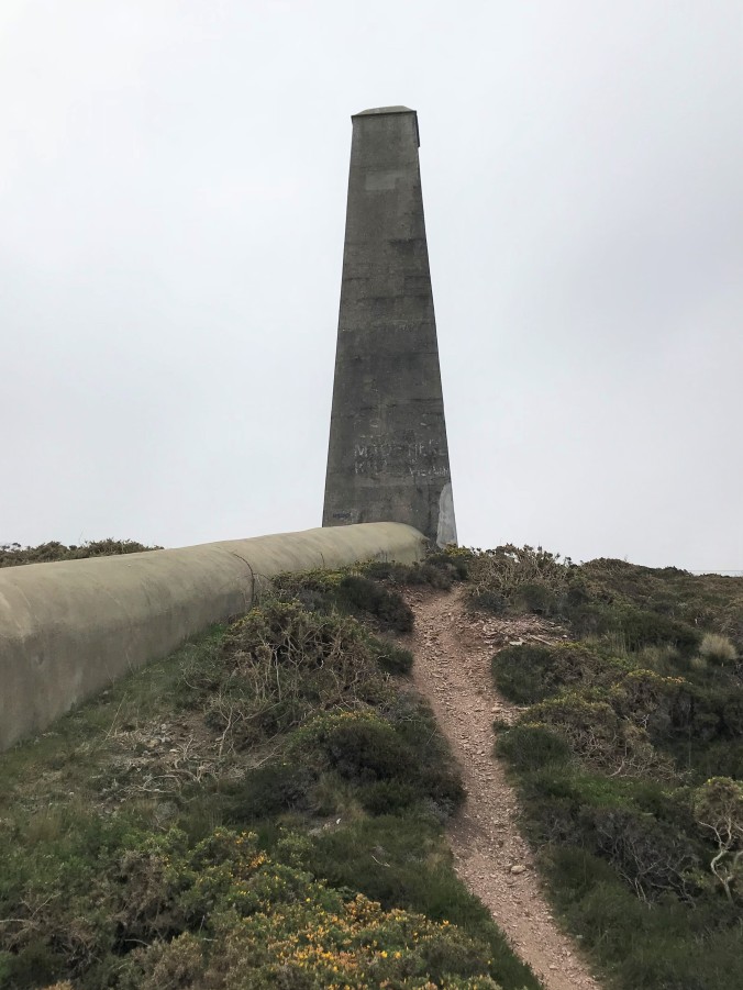 A word which made no sense to me here on the north coast of Cornwall.
I was almost in Porthtowan by now. Below me, the glorious beaches opened up and as I rounded the corner of the track to begin the descent into the village, I found the garden of my dreams.
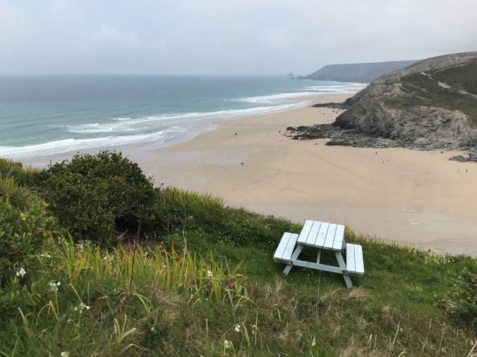 I don’t think I could improve on this.
 Porthtowan is a pleasant place and it lacks Portreath’s gloom. There was coffee. There was carrot cake. I went home happy.
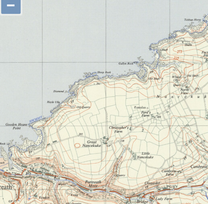
But after a few days some of the things I’d seen on the walk were niggling at me. I’ve no right to know the reason for the indefatigable fence – defence secrets must, of course, remain secret – but still I was intrigued. Here’s the air base on my 2003 map.

Thank you, Ordnance Survey
And here’s the same spot on the map on a 1962 version, 12 years after the RAF left.
Thank you, maps.nls.uk
Curious.
A bit of Googling revealed an alter ego for this remote airfield. From 1950 to 1978 the site was known as CDE Nancekuke. This led me down a whole series of online rabbit holes from official reports, to amateur explorers’ sites, via the conspiracy theorists to the frankly bonkers UFO brigade, all of which come with their own spin and levels of credibility. This was only meant to be a Sunday morning stroll and you come to indulge me in the telling of my What I did on my holiday tales, so feel free to call it a day right here.
But for a short summary which may perhaps hint at why Portreath is as it is, read on…
Jumping straight in, I read that captured war time stockpiles of German nerve agents and research documents identified GB Sarin as suitable for the UK to develop for use in potential Cold War chemical warfare. Production began at Porton Down, near Salisbury, but in 1954 it was relocated to the disused former RAF air station at Portreath – renamed Chemical Defence Establishment Nancekuke – which became the United Kingdom’s main chemical weapons research and development facility.
By 1956 international tensions were judged to have relaxed sufficiently for a halt to be called to production, but not before more 20 tons of Sarin had been stockpiled at Nancekuke. From then until the late 1970s, the facility was used for the manufacture of riot control agents such as CS gas, and the development of medical countermeasures, training aids, and the development of protective Nuclear, Biological, and Chemical (NBC) suits used by the British Forces
The closure of CDE Nancekuke was announced in 1976 and by 1978 all remaining stocks of chemical agents had been destroyed or transferred by road to Porton Down. Other chemicals were neutralized, returned to the commercial chemical industry, or buried on site alongside debris from dismantled plant and buildings. (There’s a very full account of this at https://assets.publishing.service.gov.uk/government/uploads/system/uploads/attachment_data/file/413768/20150227-FOI02229-Annex.pdf).
The underground explorers at www.subbrit.org.uk identify old quarries and abandoned tin mine shafts as dumping grounds for the waste, along with a valley where the ground level was raised by 20 feet by the dumping of rubble, waste chemicals and quantities of asbestos from demolished buildings. (www.subbrit.org.uk/sites/portreath-reporting-post/)
That would be here
Concerns have since been raised about the subsequent effects on the environment of the area and the possibility of leaching of dangerous substances into the water table or the sea.
Several hundred local civilian workers were employed at Nancekuke, all bound by the Official Secrets Act. In Parliament in 2000, Candy Atherton, MP for the area, sought to raise the above average incidence of sickness and premature death in this cohort of the local population,
The key time for the production of nerve gas…was the 1950s. During the four years from 1955 to 1959, there were 306 cases of respiratory disease—almost double the numbers for the following years… Some 41 men died—nine during employment and 32 after leaving the establishment— between 1950 and 1969… Some complicated statistical analysis was applied and the conclusion was reached that such a death rate was lower than the national average. If a small company employing 150 people lost 41 current and former employees among a relatively young and healthy cohort, alarm bells would ring…Those men were working not underground or at sea, but in a factory and a laboratory environment. (https://api.parliament.uk/historic-hansard/commons/2000/jan/18/nancekuke-base)
In his response, John Spellar, Minister for the Armed Forces, refuted her contention that something untoward had been going on.

Graffiti reads ‘…made here kills Vietnam’. Chemical weapons produced at Nancekuke were, it is believed, used offensively by the United States until 1964. Candy Atherton, MP. I am not aware of any chemical warfare agents being transferred to the United States, other than a few laboratory samples. John Spellar, Minister for the Armed Forces (https://api.parliament.uk/historic-hansard/commons/2000/jan/18/nancekuke-base)
And so back to Portreath, to the small village that has lived with that secret place up on the hill for going on 80 years. Bound officially not to tell the truth about the unexplained comings and goings, the untimely and unlikely sicknesses, but bound unofficially to hear the rumours – I’m beginning to get the smallest inkling of why you are like you are.

Fascinating. Your summary of Cornish towns did make me laugh. I read this post with increasing incredulity. My jaw fell open when I read about stockpiles of Sarin (it does not surprise me after finding out about the WW2 Anthrax test in the Bury Esturay down the road from me). Dumping chemical waste down old mine shafts does not seem a get way to dispose of it.
LikeLiked by 1 person
Thank you, Emma. My jaw hit the floor too as I read more about what I’d just walked past. But it’s a difficult balance. If all possible measures were taken to make the mind shaft option safe then that is probably the best place for the waste, but even so I wouldn’t choose to live nearby, if I had other options. That said, there was a giant noxious weapons facility nearer to me at home which is now the site of an Asda distribution centre…
LikeLiked by 1 person
It’s good that the weapons factory is no more and that people don’t actually live at that site. I would say I’d worry about working there but I know that health & safety standards are high in the UK (at the moment, who knows what will happen post-Brexit) and I used to know someone whose job it was to check these things and he took his job verry seriously.
LikeLiked by 1 person
Interesting what you found out through your research. That does indeed go some way to explaining Portreath’s oddness given the ‘grockle geld’ effect on other northern beaches. I had to smile at your other Cornish towns descriptions 🙂 I actually am quite fond of Hayle and its 3 miles of golden beaches. More so than St Ives with its jam-packed streets and expensive boutique shops. But by far I prefer the coast away from any town, like on the Lizard.
LikeLiked by 1 person
Thank you, Jude. No really, I did like Hayle. It has a Take Us As You Find Us atmosphere which cannot be said for everywhere. But it’s the coast that’s the star. So spectacular and yet so few people about.
LikeLiked by 1 person
Sarin is a bit of a blinder. But it is strange how some places, for whatever reason, fail to chime. Tadcaster in Yorkshire does that to me, no matter how often I visit. It feels like a ghost town and I always feel uneasy. Just up the road, the site of the battle of Towton – a terrible experience – doesn’t worry me at all, despite the history and all the dead who probably remain. Odd.
LikeLiked by 1 person
Yes, I definitely didn’t see Sarin coming. Couldn’t work the reference to Vietnam in the graffiti. But I agree that there are places which just don’t gel with me. Sometimes it’s because I didn’t see them from their best angle, other times it’s because I don’t think they can have a best angle, what with all of them being unlovely. I’m off to Hebden Bridge at the weekend. I have high hopes.
LikeLike
Now, that is an interesting place. Even better, take a very steep walk up to Heptonstall. The extreme west of Yorkshire is geographically stunning.
LikeLiked by 1 person
You have been burning the midnight oil. So, thank you for all that research. Very interesting if unsettling, unpleasant even. I was expecting more Poldark than Sarin with black-clad horsemen racing pointlessly back and forth along the cliffs. But that’s the intrigue of distance walking – it might be all goldfinches on flowering gorse, it might be nerve agent factories and dumps. I’ve long planned walking the SW coastal path and this post – despite the stock cars, odd towns and weapons of mass destruction – hasn’t changed my mind. Thanks again. And you’re quite right – most importantly there ought to be carrot cake. D
LikeLiked by 1 person
Thank you, David, and yes my not quite under control inner research nerd did break out this time. All that I have seen of the SWCP so far has been good and I heartily recommend it. I’ll look forward to reading your take on it in the fullness of time. It’s going to take me a good ten years at my current rate so you’ll undoubtedly overtake me on the way.
LikeLike